Drier pre-monsoon – Harmful impact on crop production

From Current Affairs Notes for UPSC » Editorials & In-depths » This topic
IAS EXPRESS Vs UPSC Prelims 2024: 85+ questions reflected
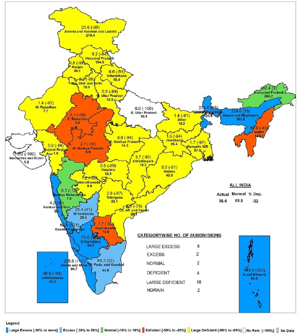
Context: According to the latest data by the India Meteorological Department, Pune (IMD), pre-monsoon rainfall was in the ‘large deficient’ category in 18 of the 36 hydrological sub-divisions as of the third week of April.

Why is a drier monsoon important?
- There is no clear trend illustrating how a drier pre-monsoon affects the onset of the southwest monsoon. But from an agricultural perspective, pre-monsoon rainfall is important for a lot of crops.
- Rainfall during this period, called ‘tea shower’ in Assam, is very important for tea plantations across the northeastern state for increasing the quality and aroma of the flush as well as productivity.
- In West Bengal, the pre-monsoon showers are called ‘Kalboishaki’ and are important for spring rice crops.
- In southern India and along the Konkan coast, where it is called ‘mango showers’, the pre-monsoon rainfall helps in the ripening of the mangoes, while also preventing the fruit from falling off the branches before they ripen.
- Pre-monsoon rainfall also has an effect on the quality of both litchi and coffee crops.
The recent data highlighting the rainfall in sub-divisions
- The data considered is for the period March to the third week of April.
- Hydrological sub-divisions of IMD are demarcations based on the climate of a region.
- Two divisions — East Uttar Pradesh and Saurashtra and Kutch — after March had no rainfall, the data showed.
- Only eight sub-divisions had ‘large excess’ rainfall. Madhya Maharashtra and Arunachal Pradesh were the only two subdivisions with ‘normal’ rainfall, according to IMD.
- Even in the peninsular region of India, which till the third week of April had a wetter pre-monsoon, the variation is stark.
- The western sub-divisions of peninsular India experienced ‘excess’ to ‘large excess’ rainfall, the IMD data showed.
- The eastern sub-divisions Telangana, coastal Andhra Pradesh and Yanam as well as Rayalaseema had a drier pre-monsoon.
Status of India as a whole
- The country as a whole experienced a drier pre-monsoon season, with a current deficiency of 32 per cent compared to what it normally receives at this time of the year (March to the third week of April 2022).
- According to IMD, a month-wise analysis showed that the country had a rainfall departure of a little over -70 per cent in the month of March. But in April (till the third week), the country saw a normal pre-monsoon, with rainfall departure of 17 per cent over the normal.
- The overall normal pre-monsoon in April can be attributed to the peninsular region of India as well as the east and northeast regions recording a large excess rainfall of 81 per cent and 72 per cent respectively.
- Northwest and central India, on the other hand, recorded a ‘large deficient’ rainfall of -94 per cent and -66.5 per cent, respectively.
- This trend of the large variation in rainfall departure across the country is highlighted when analyzing the pre-monsoon period from March to the third week of April.
- The country witnessed a ‘deficient’ pre-monsoon — 32 lower than normal — according to IMD.
- But peninsular India and the east and northeast India received ‘excess’ and ‘normal’ rainfall respectively.
Conclusion
- India headed for ‘large deficient’ rainfall to ‘no rain’ in the pre-monsoon period and it can have a harmful impact on crop production in the country.
Practice Question for Mains
- Considering the latest data highlighting the rainfall in the subdivisions, it can be concluded that India has headed for ‘large deficient’ rainfall to ‘no rain’ in the pre-monsoon period. Examine. Also, discuss the harmful impact of this trend on crop production in the country. (250 Words, 15 Marks)
Referred Sources
If you like this post, please share your feedback in the comments section below so that we will upload more posts like this.


