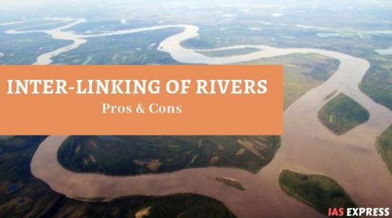
Interlinking of Rivers – Pros & Cons
Whether we realise it or not, the drinking water scarcity problem that we see in different parts of India today is a direct result of climate change. India is very vulnerable to climate change — melting Himalayan glaciers will produce floods in north India; erratic monsoons will create droughts in peninsular India.
Global action against climate change is not enough even if the Paris Agreement is followed in letter and spirit which is already weakening due to nations such as the US and Brazil walking away from it. Therefore India will have to assume the worst of impacts of global warming and tailor its programmes accordingly.
With the threat of floods and droughts looming in various parts of the country, there is no option but to make the 150-year-old idea, that is, Interlinking of Rivers (ILR) happen, and fast. The NDA government has always been in favour of inter-linking of rivers and it is to be hoped that the government sees ILR in the light of climate action, rather than a developmental move.
This topic of “Interlinking of Rivers – Pros & Cons” is important from the perspective of the UPSC IAS Examination, which falls under General Studies Portion.
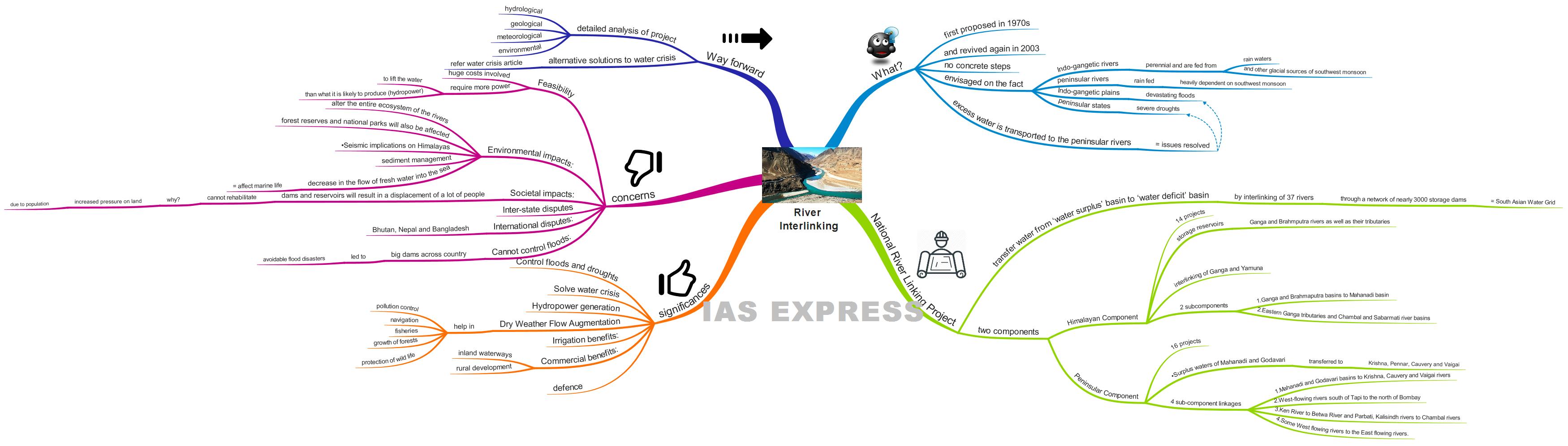
What is the Inter-Linking of Rivers (ILR)?
- The project of inter-linking of rivers was first proposed in the 1970s and revived again in 2003 however nothing concrete has been done on it.
- The concept has been envisaged on the fact that Indo-Gangetic rivers are perennial and are fed from rain waters and other glacial sources of southwest monsoon.
- On the other hand, peninsular rivers are rain fed and are heavily dependent on southwest monsoon.
- Hence, Indo-Gangetic plains witness devastating floods whereas peninsular states suffer from severe droughts.
- If this excess water is transported to the peninsular rivers, the issues of floods and droughts can be resolved.
- Therefore the interlinking of rivers will provide for equitable distribution of river waters.
What is the National River Linking Project?
The project proposes to transfer water from ‘water surplus’ basin to ‘water deficit’ basin by interlinking of 37 rivers across the country through a network of nearly 3000 storage dams to form a gigantic South Asian Water Grid.
The project has two components – 1) Himalayan Component & 2) Peninsular Component.
Himalayan Component:
- Under this, 14 projects have been identified to link different rivers of the Himalayan Region.
- It involves the construction of storage reservoirs on the Ganga and Brahmaputra rivers as well as their tributaries.
- In addition, interlinking of Ganga and Yamuna has also been proposed.
- It is expected to benefit the drought-prone areas of Haryana, Rajasthan, Gujarat, etc.
- Further, it will moderate flood in the Ganga Brahmaputra river system.
- It has 2 sub-component linkages:
- Ganga and Brahmaputra basins to Mahanadi basin
- Eastern Ganga tributaries and Chambal and Sabarmati river basins
- Below is the diagram of the proposed & completed links under the Himalayan component:
Peninsular Component:
- Under this, 16 projects have been proposed to link the rivers of South India.
- Surplus waters of Mahanadi and Godavari will be transferred to Krishna, Pennar, Cauvery, and Vaigai.
- It has 4 sub-component linkages
- Mahanadi and Godavari basins to Krishna, Cauvery, and Vaigai rivers
- West-flowing rivers south of Tapi to the north of Bombay
- Ken River to Betwa River and Parbati, Kalisindh rivers to Chambal rivers
- Some West flowing rivers to the East flowing rivers.
- Below is the diagram of the proposed & completed links under Peninsular component:
What are the significances of rivers interlinking?
Control floods and droughts
- India receives the majority of its rainfall in only 3 months of a year i.e., from June to September.
- Most of such rainfall occurs in northern and eastern India whereas southern India remains water deficit.
- Thus linking will provide a two-way advantage, that is, controlling of floods as well as droughts.
- The project envisages the supply of clean drinking water and water for industrial use amounting to 90 and 64.8 billion cu.m respectively with a view to satisfying the demand by 2050.
Hydropower generation
- The building of dams and reservoirs are key components of the interlinking project = About 34,000 MW of total power could be generated if the whole project is implemented.
- Thus river interlinking has the potential to resolve the electricity issues of the industrial, agricultural as well as rural households.
Dry Weather Flow Augmentation
- Transfer of surplus water stored in reservoirs during monsoon and releasing it during the dry season will facilitate a minimum amount of dry weather flow in the rivers
- This would help in pollution control, navigation, fisheries, growth of forests, protection of wildlife, etc.
Irrigation benefits:
- Indian agriculture is primarily dependent on monsoons which is not reliable = failure of crops due to water scarcity as we have witnessed in the Vidharba region of Maharashtra.
- The project claims to provide additional irrigation facilities of about 35 million hectares in the water deficit western and peninsular regions.
Commercial benefits:
- In the long run, interlinking of rivers will have commercial benefits.
- Canals can be utilised as inland waterways which will help in faster movement of goods from one place to another.
- Moreover, rural areas will develop with diverse income sources such as fish farming, etc.
Defense
- The Project is expected to strengthen the security of the country by an additional waterline of defense
What are the concerns with the implementation of the project?
Feasibility of the project:
- The total cost of the project is expected to be around 5,60,000 crore at the 2002 price level.
- Besides, the total cost with respect to the usage is expected to be 1,35,000 crore for power generation and 4,25,000 crore for irrigation and water supply.
- In addition to the huge costs involved, the project would require huge engineering structures which also need constant monitoring.
- Furthermore, Interlinking of rivers will require more power to lift the water than what it is likely to produce (hydropower).
Environmental impacts:
- The project will alter the entire ecosystem of the rivers = affect fisheries, flora and fauna, wetlands and other ecosystems.
- In addition to this, forest reserves and national parks will also be affected due to the construction of various links. For example, Ket-Betwa link is expected to put in danger 4000 hectares of the Panna National park which is also an important tiger reserve.
- Seismic implications on the Himalayas due to the weight of millions of liters’ of water.
- The concerns about sediment management, particularly on the Himalayan system has been rising.
- When the idea is to transfer water from the ‘surplus’ Himalayan river systems to ‘deficit’ basins of the southern part of India, the differential sediment regime defining the flow regimes need to be considered.
- This will lead to changes in ecosystem structures in both parts.
- More importantly, the project will lead to a decrease in the flow of fresh water into the sea = affect marine life.
Societal impacts:
- The building of dams and reservoirs will result in a displacement of a lot of people which cannot even be estimated currently.
- For example, Tehri Dam in Uttarakhand resulted in the submergence of more than 40 villages along with the partial submergence of 72 villages = caused displacement of around 1 lakh people.
- Moreover, there is also a question arises – Where could we rehabilitate these displaced people when there is increased pressure on land due to the rising population?
Inter-state disputes
- Water is a state subject in the Indian constitution.
- Many states including Kerala, Andhra Pradesh, Assam, and Sikkim have already opposed ILR projects.
- There has been a dispute between Karnataka and Tamil Nadu over the sharing of water from river Cauvery.
International disputes:
- Interlinking of rivers will likely to increase the number of conflicts not only at the state level but also of the international level.
- Some of the inter-linking of rivers schemes has international implications, with a possible impact on countries such as Bhutan, Nepal, and Bangladesh
- Bangladesh strongly opposes the move to transfer the Brahmaputra water to the Ganga.
- Therefore, Water transfer in the Himalayan component needs to consider the effects on the neighbouring countries.
Cannot control floods:
- It is doubtful whether interlinking projects can provide flood proofing. Theoretically, a large reservoir can help moderate floods in the downstream areas. However, in the case of India experiences have been different.
- Big dams such as the Ranganadi dam, the Damodar dams, the Farakka and Bansagar dams, and the Hirakud dam have brought avoidable flood disasters to Assam, West Bengal, Bihar, and Odisha, respectively.
Way forward
It has been claimed that the project will cause more harm than good to the country’s resources. However, its possible advantages cannot be ignored particularly in the context of growing concerns of climate change. Hence it is crucial to do a detailed hydrological, geological, meteorological and environmental analysis of the project before moving ahead. Until then, the government should focus on alternative solutions to the water crisis in India.