I. Aloft Pressure Patterns and Circulation
Aloft Conditions
In the atmosphere, aloft refers to the upper levels of the troposphere. Several factors contribute to the unique pressure patterns and circulation observed at these altitudes.
- Almost No Friction: Unlike surface winds that encounter friction with the Earth’s surface, winds aloft experience minimal frictional resistance.
- Faster Movement: Due to the reduced friction, winds aloft can move at higher speeds compared to surface winds.
- Winds Along Latitude: The general direction of winds aloft is parallel to the latitude lines.
- Coriolis Force: The Coriolis force, resulting from the Earth’s rotation, plays a crucial role in the circulation patterns of winds aloft. It always acts at a 90-degree angle to the moving object rather than the pressure gradient.
- Only One Pressure Gradient: There is typically only one pressure gradient force operating aloft, leading to distinct wind patterns.
Pressure Patterns from Equator to Poles
Aloft pressure patterns exhibit specific characteristics depending on their location relative to the equator and poles.
- Equator: At the equator, aloft pressure is generally high due to descending air masses.
- Poles: In contrast, the poles experience relatively low aloft pressure because of ascending air masses.
Geostrophic Winds: Equator to Poles Aloft
When winds move from the equator towards the poles aloft, they are influenced by various forces and factors.
- Pressure Gradient Force: Under the influence of the pressure gradient force, which is stronger at higher latitudes, winds move from areas of higher pressure to lower pressure.
- Almost No Friction: The absence of significant friction aloft allows wind speeds to become exceptionally high.
- Coriolis Deflection: As winds accelerate, the Coriolis force causes a deflection that maximizes at high wind speeds. Consequently, the winds become parallel to the isobars (lines connecting points of equal pressure).
- Geostrophic Balance: This balance occurs when the Coriolis force and the pressure gradient force are perfectly counterbalanced, resulting in geostrophic winds.
II. Rossby Waves: Meandering Upper Tropospheric Winds
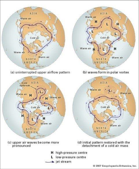
Rossby waves, also known as meandering upper tropospheric winds, play a crucial role in atmospheric circulation.
- Formation: Rossby waves are formed due to the Earth’s spherical shape and the atmosphere’s attempt to maintain angular momentum progressively towards the poles.
- Amplitude Fluctuation: Rossby waves exhibit varying amplitudes as they meander. They cycle through different shapes, ranging from nearly straight east-west paths along latitudes to nearly north-south paths along meridians before returning to east-west movement.
- Index Cycles: The waves go through cycles known as index cycles. These cycles alternate between high index (almost straight) and low index (almost curved) paths. For example, a low index pattern may be followed by a high index pattern, then a low index pattern again, and so on.
- Energy Transfer: The meandering index wave pattern of Rossby waves serves as the primary mechanism for energy transfer from low latitudes to high latitudes. This energy balance is essential for atmospheric dynamics.
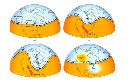
Pressure Patterns Induced by Rossby Waves
The meandering Rossby waves induce pressure patterns both aloft and at the surface, contributing to the overall atmospheric circulation.
- Meandering Rossby Waves: With their index cycles, Rossby waves create dynamic pressure cells aloft, which induce corresponding pressure patterns on the surface.
- Local Dynamic Pressure Cells: These pressure cells, created by Rossby waves, result in a series of alternating high and low pressure cells both aloft and on the surface.
- Traveling Pressure Patterns: The pressure patterns induced by Rossby waves travel along latitudes from west to east on the surface.
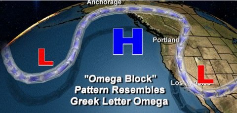
Influence on Mid-Latitude Weather Patterns
The complex mid-latitude weather patterns are significantly influenced by Rossby waves and associated low-pressure systems.
- Rossby Waves and Low Pressure: Rossby waves play a crucial role in the formation and behavior of mid-latitude low-pressure systems.
- Complexity of Weather Patterns: The mid-latitude weather patterns cannot be solely explained by the meridional cells and circulation described in Ferrel’s model. The interaction between Rossby waves, low-pressure systems, and other atmospheric factors contributes to the complexity of mid-latitude weather.
Jet Streams: Powerful Upper Tropospheric Winds
What are Jet Streams?
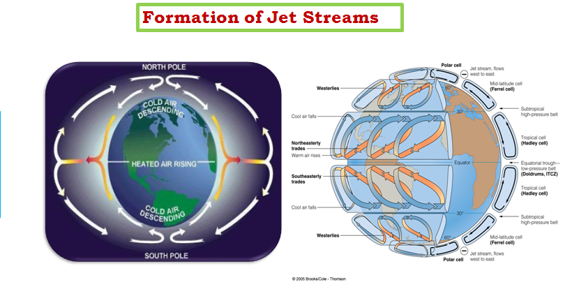
Jet streams are narrow bands of exceptionally fast-moving air found in the upper troposphere. They were discovered during the World Wars and are embedded within the larger upper tropospheric winds known as Rossby waves. Jet streams are characterized by their high velocity, with core speeds often exceeding 300 km/hr.
Features of Jet Streams
Jet streams possess distinct features that set them apart from the surrounding atmospheric conditions:
- Part of Upper Tropospheric Westerlies: Jet streams are a part of the broader upper tropospheric westerly winds that flow from west to east.
- More Strong Gradient: Jet streams have a stronger pressure gradient compared to the surrounding air, contributing to their high velocity.
- Higher Velocity: Jet streams move at much higher velocities than the average winds in the upper troposphere.
- Part of Meandering Waves: Jet streams are integral components of the meandering Rossby waves themselves, following a similar path and exhibiting similar characteristics.
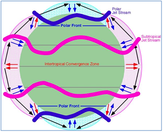
- Location at the Margins of Vertical Cells: Jet streams are typically located at or above the boundaries of vertical cells in the atmosphere. They exist between the Hadley and Ferrel cells, as well as between the Ferrel and Polar cells. The sharp temperature contrast between these cells adds velocity to the geostrophic winds that form jet streams.
- Meandering Nature: Jet streams exhibit a meandering pattern, with loops and bends along their path. This meandering is influenced by the index cycle, similar to Rossby waves in the mid-latitudes.
- Role in Navigation: Jet streams play a crucial role in aviation and navigation, as they can significantly affect the speed and efficiency of aircraft.
Types of Jet Streams
Jet streams can be categorized into two main types: permanent and temporary jet streams.
Permanent Jet Streams
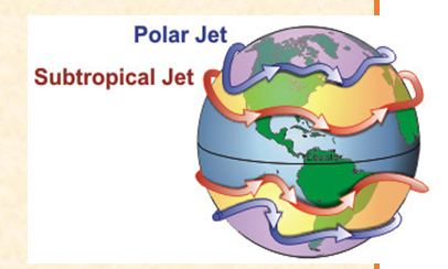
- Subtropical Westerly Jet Streams: These jet streams are located around 30-35 degrees latitude, between the Hadley and Ferrel cells. They play a crucial role in the sudden onset of monsoons on the Malabar coast, known as the Monsoon Burst. They are also responsible for monsoon breaks, which result in drought conditions. Additionally, they are associated with the formation of weather disturbances known as western disturbances.
- Polar Jet Streams: The polar jet streams are found around 60-65 degrees latitude and are embedded within Rossby waves at the junction of the Ferrel and Polar cells. They go through an index cycle, similar to Rossby waves, resulting in meandering loops that change with time.
Temporary Jet Streams
- Polar Night Jet Streams: These jet streams develop at the poles during the night when there is a sharp contrast in temperature. This contrast creates a strong pressure gradient, leading to the formation of jet streams.
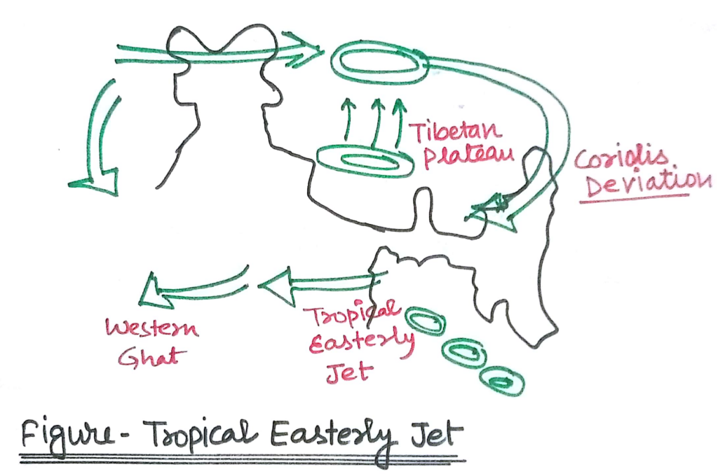
- Tropical Easterly Jet Streams: Formed over South Asia during the summer, the tropical easterly jet streams are influenced by the strong heating of the Tibetan plateau (Tibetan low). They play a vital role in the formation and progression of Indian monsoons and are part of the regional vertical cell.
- Somali Jet Streams:
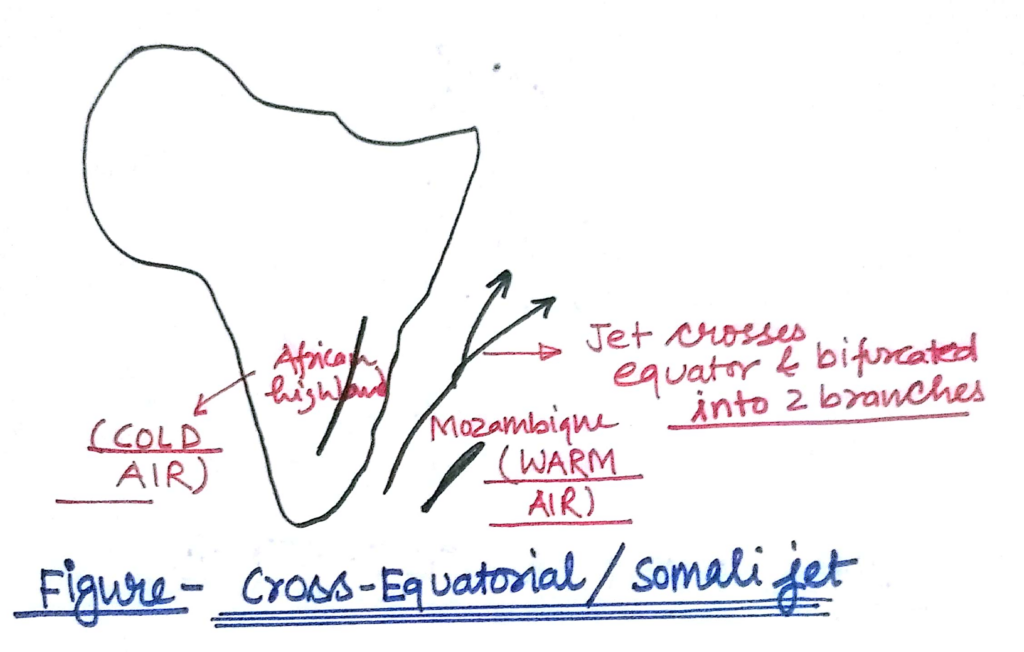
- Also known as Findlater jet streams, the origin of Somali jet streams is not well known. They aid the progress of the southwest monsoon towards India at a rapid pace. These jet streams occur in the summer along the East-African slope, strengthening the permanent high near Madagascar. The low-level jet of the Somali jet stream path coincides with the zone of coastal upwelling and is bifurcated and deflected by the Ethiopian highlands before leaving the African valley near Somalia. The direction of the jet stream reverses with the onset of the summer monsoon, flowing from south to north.
- In winter, the current direction of the Somali jet stream is north to south, running southwards from the coast of Arabia to the East African coastline. However, with the advent of the summer monsoon, it reverses its direction and flows from south to north. The weakening of the Somali jet stream can result in drought conditions in South Asia.
Jet streams, with their powerful winds and meandering nature, significantly impact atmospheric circulation and weather patterns. Understanding these jet streams is crucial for various applications, from aviation to weather forecasting.

Responses